Inland ENCs are electronic inland navigation charts that differ fundamentally from paper charts. The electronic storage of the geographical data as vector data allows a correct presentation in all levels of detail and ensures a reliable and clear presentation of the information. Inland ENCs are produced, updated and published either by commercial providers or by waterway administrations. Special software (Inland ECDIS) is required for the presentation of Inland ENCs. An ECDIS Viewer is part of the navigation information system on board ships and thus a massive support for masters when navigating.
Up-to-date geodata of the river course as well as the display of vessel traffic in the form of a real-time traffic information system support the captain in monitoring and carrying out ship transports and voyages. In order to contribute to the traffic safety and efficiency of inland navigation, reliable updated geodata of the water depth are published in a timely manner so that an optimal, safe route can be chosen. Inland ENCs are available for the entire Austrian section of the Danube for download, as web-based charts or in the form of paper charts.
The regulation of Inland ENCs and Inland ECDIS navigation systems is regulated EU-wide in the RIS Directive on Inland Waterways of the Community of the European Parliament and the Council, which entered into force on 20 October 2005.
News and project status
As part of the diligent compliance with the legal implementing regulation of the EU Commission, the chart information in Austria was updated to the latest Inland ECDIS Standard 2.4 in 2019. For the entire Austrian Danube and the common border areas with Germany and Slovakia, the depth data were issued in the form of bathymetric Inland ENCs.
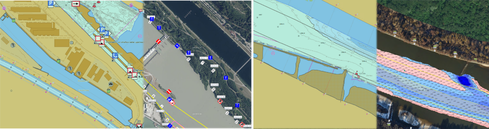
viadonau will in future publish timely and reliably updated information on water depth in the form of bathymetric Inland ENCs. As a rule, the free-flowing stretches (Wachau and east of Vienna) are updated annually, shallow areas (according to DoRIS shallow areas < 2.50 m fairway depth related to RNW) monthly and impounded areas every 4-5 years. In contrast to the previous procedure, the total records of the two free-flowing stretches are now only updated once a year in the Inland ENCs - conversely, the relevant shallow points are updated monthly. On the one hand, this provides navigation with a much more accurate picture of the situation in the Inland ENCs (especially after dredging), and on the other hand it harmonises the information provided on the DoRIS shallow water website. The topographic data were extended by numerous new objects/information such as gravel islands, guide structures, restricted areas, gauging stations and lands, and the shorelines were adjusted on the basis of current aerial photographs. Inland ENCs are available for download for the entire Austrian section of the Danube, as web-based maps or in the form of a route atlas.
In cooperation with the waterway administrations of the Danube and with the ECDIS software producers, training videos (RADARpilot 720, TRESCO) were developed to explain the use of Inland ECDIS Viewers to captains in a practical way and to support them in their daily tasks.
With the amendment of the Waterways Traffic Regulations (BGBl. II No. 204/2023, § 4.07), an Inland ECDIS obligation was introduced, effective from June 2024. This means that vessels must be equipped with Inland ECDIS devices, though certain types of vessels are exempt. The obligation to carry Inland ECDIS equipment, which has already been in place for several years for German inland waterways, for example, makes a significant contribution to increasing the safety of navigation on waterways.
The project made a substantial contribution to the implementation of measure
3. Improve and enhance fairway information of the Action Programme for the Danube 2022 and the workpackage 06. Developing corridor-wide river information services and other information technologies and strengthen links to other modes of transport of the Action Programme Danube 2030.
