Completion of the conception and pilot project phase
With the conclusion of the first evaluation phase of the Pilot Project Bad Deutsch-Altenburg in 2016, the conceptual and pilot project phase of the Integrated River Engineering Project for the Danube East of Vienna was brought to an end. On the basis of the findings, as well as developments in waterway and traffic management, a new direction is now taken with the Catalogue of Measures, drawn up to achieve ecological and nautical conservation targets on the Danube east of Vienna.
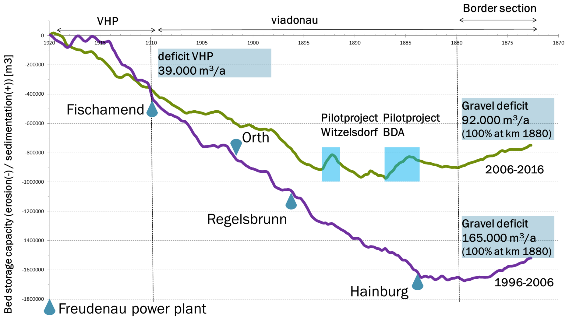
Initial success in the reduction of riverbed erosion
The latest analyses of the development of the riverbed on the Danube east of Vienna between 1996 and 2016 show that erosion of the riverbed declined significantly in the second decade of the survey period. The annual gravel deficit has decreased by more than 40 per cent. The reasons for this are the pilot projects at Witzelsdorf and Bad Deutsch-Altenburg, as well as a modified maintenance strategy. Since 2009, gravel, which is dredged during the course of maintenance work, is systematically shipped upstream and dumped there. From 2015 onwards, average distances for the transportation of material relating to riverbed management have increased significantly (approximately 10 kilometers on average), meaning that the gravel remains substantially longer in the section of the Danube.
In 2017, a bedload trap was created in the area of the Treuschütt ford. This trap represents an additional source of material for bedload redistribution that is independent of maintenance activities. In the Hainburg area, another bedload trap was established in 2021. Gravel from these areas is dumped at the beginning of the viadonau maintenance section in order to counteract the deepening of the riverbed as effectively as possible.
Combined gravel deficit east of Vienna 1996-2016 (profile distance 100m)
The annual gravel deficit decreased by over 40 per cent between 2006-2016 compared to 1996-2006.
Ongoing measures
- Continuous bedload management
Since 2016, large quantities of gravel have been relocated - i.e. dredged, transported upstream and dumped - as part of bedload management. On the one hand, this has enabled the minimum fairway parameters for navigation to be largely achieved. On the other hand, the gravel remains substantially longer in the section of the Danube. This is an essential contribution to the stabilization of water levels. Since summer 2017, a bedload trap has been put into operation in the area of the Treuschütt ford in order to obtain additional gravel for bedload management here and to improve the fairway conditions in the area of the ford. In 2021, a second bedload trap was added in the Hainburg area. The material from the bedload traps is transported almost 20 kilometers upstream and dumped in scours. This measure also makes an active contribution to the dynamic stabilization of the Danube bed and the water level. - Dynamic LIFE Lines Danube (DLLD)
The Dynamic LIFE Lines Danube project aims to maintain and improve the Danube wetlands in eastern Austria and western Slovakia. In the frame of the co-funded project viadonau will conduct the re-connection of the two side-arm-systems 'Spittelauer Arm' and' Haslau-Regelsbrunn" with the Danube river. The reconnection of the Spittelauer arm has been completed in 2021. - DANUBE4all (Horizon Europe)
The DANUBE4all project is being implemented with lead partner BOKU (University of Natural Resources and Life Sciences, Vienna) and an international consortium. The core output of the project is the science-based development of the Restoration Action Plan for the Danube basin, which considers biological diversity, flood risk and sediment continuity. On the part of viadonau, the creation of natural bank structures in the area of the ‘Orther Arm’ and the ‘Paradeisinsel’ is envisaged. For this purpose, bank reconstruction and groyne root lowering as well as the improvement of an inflow opening in the side arm system are planned. By these measures the character of the island (Paradeisinsel) should be strengthened. - MERLIN (Horizon 2020 / Green Deal)
This Europe-wide project of the Horizon 2020 program is looking for new, widely applicable solutions for restoring the functions of European freshwater ecosystems. viadonau is contributing the know-how gained in the Catalog of Measures for the renaturation of waterways as well as a bank restoration as a pilot project to the project. More information about the project can be found here. - LIFE WILDisland
The project WILDisland, funded by the LIFE program, focuses on the "wild islands" of the Danube. viadonau will renaturalize the area of the so-called Schwalbeninsel in particular in this project. More information about the project can be found here. - LIFE Boat 4 Sturgeon
The overall objective of this LIFE species conservation project is to help save the four remaining Danube sturgeon species from extinction: the Sterlet, the Waxdick, the Sternhausen and the Hausen. To this end, the viadonau ship MS Negrelli is being converted into a floating fish breeding station. Read more here. - Scour protection Hainburg
In the area of the port of Hainburg, there is a deep scour in the main stream, which still shows a tendency to deepen. This scour has been secured against further deepening in fall 2023. This not only counteracts the deepening of the Danube in this section but also improves the stability of the bank protection of the town of Hainburg.The construction work was successfully completed in October 2023. Biotic monitoring is currently taking place and is due to be completed in spring 2024, with the focus on macrozoobenthos and fish. - Christian Doppler Laboratory Sediment Research and Management
Within the frame of a research cooperation with the University of Natural Resources and Life Sciences, Vienna (BOKU) scientific accompaniment and monitoring of measures is carried out. The laboratory especially tackles the questions about sediment management (e.g. material composition and quantities, sediment abrasion) in the context of river bed degradation and tries to further understand morphodynamic processes of the Danube River. Link to the CD SED website. - Christian Doppler Laboratory „MERI“
Christian Doppler Laboratory for Meta Ecosystem Dynamics in Riverine Landscapes systematically and comprehensively investigates the complex meta-ecosystem of the Austrian Danube to understand the impact of human activities on biodiversity and ecosystem services and to develop sustainable ecological measures for future management of the Austrian Danube. In the Catalogue of Measures, it serves as a scientific superstructure over the monitoring programmes at measure level. Through the CD Laboratory, the positive ecological effects of the river engineering projects can be optimised on an ongoing basis.
- Ongoing planning activities
Planning and preparatory work for many individual measures listed in the Catalogue of Measures are in progress. - Evaluation of project impacts
For the pilot projects Bad Deutsch-Altenburg and Witzelsdorf studies are being undertaken to determine the medium and long term effects of the construction measures on the Danube, as well as on plants and animals of the Danube floodplains.
Measures implemented
- Mooring Place Wildungsmauer
At the river bank of Wildungsmauer, an existing small craft landing stage has been expanded into a public mooring place for freight navigation in 2022/2023. In addition, a shore power system was installed to provide the ships with an environmentally friendly power supply while they are in port. Furthermore, a new slip ramp significantly expands the fire departments' ability to act in the event of accidents on the Danube. The measure was part of the EU-funded CEF project "FAIRway works! in the Rhine-Danube Corridor". - Renovation and extension of the harbor spur Servicecenter Carnuntum
The condition of the port spur of the viadonau servicecenter for the easternmost section of the Austrian Danube made a general rehabilitation necessary. As part of the rehabilitation, the spur was extended in 2022/2023 to provide better protection for the service and authority harbor. The tacking facilities were also renewed. - Mooring Place Fischamündung
In the area of the renaturalized mouth of the Fischa river, in 2022 a mooring place in the form of four dolphins (steel piles for securing ships) was built. This mooring place supports the operation of the Danube waterway and the bedload management and can be used in case of emergencies. - Revitalization of the Fischa’s river mouth (INTERREG SK-AT)
In the frame of the INTERREG project Alpine Carpathian River Corridor viadonau implements the revitalization of the river mouth of the Danube tributary ‘Fischa’ in Lower Austria. Works have been implemented in fall and winter 2019. By removing riverbank reinforcements on both banks, the river mouth is returned to a more natural shape and improved ecologically. In the fall of 2020, a downstream connected biotope was created in the estuary. Significant steps towards the improvement of the habitat network of the Danube are made. Read more in our project database. - Island Wolfsthal
By lowering existing groyne parts in its’ riparian vicinity, a back channel was created in the area of river-kilometer 1877 in the year 2019. Thereby a small side arm was shaped between an existing gravel bank and the main stream of the Danube River, forming a valuable wave protected area as well as strengthening the character of the gravel bank as an island. The island represents an important refuge area for animals of the Danube wetlands. The measure was implemented in cooperation with the project DANUBEparksCONNECTED (Interreg DTP - Programm), leaded by the Donau-Auen Nationalpark. Find more information about the project here. - Optimization of groynes at Treuschütt
Ford Treuschütt was considered to be one of the Danubes’ critical sections for navigation, restricting the available fairway depth for inland waterway transport in Austria. With the optimization of the existing low water regulation structures in august and september 2018, the minimum fairway parameters were achieved and the riparian area ecologically improved. - Relocation passenger landing stage Hainburg
With the relocation of the existing passenger landing stage at Hainburg in summer 2018, the safety of navigation in the Danube section east of Vienna was improved. Mooring vessels no longer protrude into the navigation channel and represent an obstacle for traffic. Furthermore, it was possible to move the navigation channel towards the natural depression zone of the river bed, reducing the efforts for maintaining safe and economic fairway conditions. - Christian Doppler Laboratory "IM Fluss"
Scientific accompaniment and monitoring were carried out in particular by the Christian Doppler laboratory "IM Fluss" (Innovative methods in river water monitoring, modeling and river engineering) from 2010 - 2017. For further information, please visit: http://www.cdlabor-imfluss.boku.ac.at/. - Optimisation of the ford at Bad Deutsch-Altenburg
At the beginning of 2017, fairway navigability was significantly improved by the adaption the groynes at the ford at Bad Deutsch-Altenburg, leading to reduced maintenance costs. The objective was to create defined minimum water parameters in the fairway (a fairway depth of 2.50 in accordance with the low navigable water level regulation LNWL) as well as to approach a balanced state between sedimentation and erosion of the riverbed. - Pilot test bedload management
Bedload management was tested in 2015 with some 68,500 cubic meters of gravel, which were transported more than 18 kilometers upstream. The focus of the investigations was on the effects this management approach had on the riverbed, along with economic aspects, considering cost of implementation, equipment used, weekly performance, etc. - Optimisation of the ford at Petronell
In autumn 2015 the groynes and the training structure at the ford at Petronell were raised slightly in order to eliminate the previously deposited accumulation of gravel in the fairway. The objective was to create defined minimum water parameters in the fairway (a fairway depth of 2.50 in accordance with the low navigable water level regulation LNWL) as well as to approach a balanced state between sedimentation and erosion of the riverbed.
Pilot project phase
Completed conceptual and project phase pilot projects
- Pilot Project Bad Deutsch-Altenburg:
Construction completion in 2014; TEN-T project - Pilot Project Witzeldorf:
Construction completed in 2009; TEN-T project - Riverbank restoration Thurnhaufen:
Completion 2006; LIFE project in cooperation with the Donau- Auen National Park - Side-arm reconnection Schönau:
Completion 2004; LIFE project in cooperation with the Donau- Auen National Park - Side-arm reconnection Orth:
Completion 2002; LIFE project in cooperation with the Donau- Auen National Park - Side-arm reconnection Haslau-Regelsbrunn:
Completion 1998