Gauging, data collection and processing of measuring data
viadonau operates an extensive network of measuring devices at suitable locations along the Danube, March and the border section of the Thaya, which continuously records data on water levels, water temperature, solid materials, ground water levels and temperature as well as the conductivity of ground water. In the course of this activity, the measuring network is constantly monitored, maintained and adapted to the state-of-the-art or optimised (e.g. regarding reliability, accuracy and level of automation). Furthermore, the collected data are subjected to continuous quality inspections, processed and interpreted.
The information is used for hydrological analyses, studies and examinations or made available in real time for a wide circle of users and customers. For navigation, the operation of locks, viadonau´s conservation teams as well as several public authorities and emergency services reliable data is essential – particularly during extreme events (floods and low water). In Austria´s hydrographical yearbook the collected data is jointly disseminated and verbally interpreted.
Gauging at the Danube, the March and the Thaya contributes substantially to the Austrian water management and international projects. It is the basis for navigation and the operation and maintenance of the waterway.
Partners
- Federal Ministry for Agriculture and Forestry, Environment and Water Management Dep. IV/4 (Hydrographic Office)
- Hydrographic services and protective water management of the Länder
- Flood Protection Associations
- Verbund
News and activity status
The provision of real-time data and information generated from it is constantly being expanded (e.g. bridge clearance heights in real time, depth data in the ECDIS viewers). The measuring devices at the gauging stations are always kept state-of-the-art by viadonau. High-priority gauging stations are increasingly equipped with redundant measuring and remote data transmission systems. The aim is to be able to continue to provide up-to-date and meaningful measurement data even if a measurement system fails.
The data bases relevant for the Danube and March / Thaya are continuously made available to the corresponding provincial services and published on their websites. viadonau therefore makes a significant contribution to the operation of flood protection forecast systems.
Three existing groundwater measuring points will become inaccessible due to an ecological project and will therefore have to be discontinued. A replacement has already been created in anticipation of this: Three new boreholes have been sunk and equipped with state-of-the-art measuring devices. This means that measurements can be carried out at the old and new sites in an overlapping manner. The comparison of the measurement data enables an assessment of the data quality at the new sites.
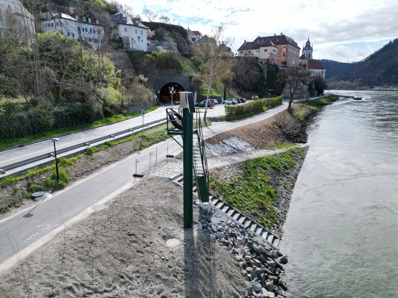
Between 2022 and 2024, the Dürnstein measuring station, which was previously in a poor structural condition, was renovated. After obtaining the relevant permits, a foundation was built and the steel structure for the measuring point (photo below) was placed on top of it. The high steel structure is necessary in order to be able to place the electronic measuring devices above flood level. The photovoltaic system, which enables the measuring devices to operate completely independently, can be identified in the photo. A blue tide gauge is mounted on the water level steps, which is used to calibrate the measuring devices.
The Dürnstein measuring station is essential for navigation at the mooring place there and the Weißenkirchen ford (km 2014.6 to km 2013.5), for monitoring renaturation measures and for fulfilling the legal mandate of the hydrographic service and passing on information for shipping.
The activity makes a substantial contribution to the implementation of measure
03. Improve and enhance fairway information of the Action Programme for the Danube 2022 and to work package 01. Developing waterway infrastructure and fostering innovations in waterway management of the Action Programme Danube 2030.
Last change:
22. 04. 2026