Rehabilitation of the March flood protection dam
viadonau is carrying out the general rehabilitation of the flood protection dams along the Morava and Lower Dyje rivers as well as the feeder streams Weidenbach, Sulzbach, Jedenspeigenbach and Zaya on behalf of the water boards for the Morava flood protection dam Marchegg - Zwerndorf and for the Morava-Thaya flood protection dam Angern - Bernhardsthal.
Project overview
Project objective
The project objective was set to rehabilitate the dams on the Morava and Lower Dyje rivers to protect the hinterland according to the state of the art and to bring them continuously up to the level of a hypothetical flood that statistically occurs every 100 years with an additional safety height of at least 70 cm. In the 3rd quarter of 2015, it was also decided to rehabilitate the dam crest in the Bernhardsthal area. The total length is about 80 km and provides safety for about 18,000 citizens in ten municipalities.
Schedule and milestones
After the floods in spring 2006, the entire dam system along the Morava and lower Thaya rivers was geotechnically examined and subjected to a condition assessment. Based on this and on the risk potential for settlement areas and infrastructure facilities in the event of dam failure, a priority ranking for the rehabilitation of the flood protection facilities was worked out and immediate measures defined. An environmental impact assessment (EIA) had to be carried out for two project sections. This has resulted in further official requirements for these sections.
Project start: 2006
Immediate measures completed: End of 2007
EIA project construction completed: Mid-2008
Overall completion of flood protection: 2013
Bernhardsthal dam crest rehabilitation decision: mid-2015
Emergence management: until 2016
Management of gravel column waters: until 2020
Construction period for the Bernhardsthal lot: until 2019
Monitoring required by decision: until 2034
Project description
Initial situation
Heavy rainfall and snowmelt in the catchment area of the Morava and Thaya rivers caused a 100-year flood with a peak discharge of over 1,400 m³/sec in April 2006. This led to dam breaches in Dürnkrut, Grub and Stillfried. The damage caused by the flood amounted to more than EUR 72 million.
Procedure
In order to be able to use the available budget funds in a targeted and economical manner, the dams on the Morava and Thaya rivers were divided into sections and a selection of evaluation criteria was made for the comprehensible classification of priorities. The entire dam system was geotechnically examined to determine the degree of damage to the dams. In addition, the hazard potential for settlement areas and infrastructure facilities in the event of dam failure was used to determine the priority ranking. The project was expanded to include the rehabilitation of the feeder streams Sulzbach, Jedenspeigenbach and Zaya, which were not included in the original priority ranking. In the 3rd quarter of 2015, it was also decided to rehabilitate the dam crest in the Bernhardsthal area. This resulted in the following structure:
Phase 1: Immediate measures after the 2006 floods.
Phase 2: EIA projects
- "Angern-Mannersdorf-Stillfried" - length approx. 5.961 km
- "Waidendorf-Dürnkrut-Jedenspeigen" - length approx. 4.707 km
Phase 3: Rehabilitation of the remaining dam sections
- "Marchegg Bahnhof-Zwerndorf" - length approx. 17.569 km
- "Weidenbach" - length approx. 4.295 km
- "Zwerndorf-Angern" - length approx. 1.350 km
- "Stillfried-Grub-Waidendorf" - length approx. 5.535 km
- "Sulzbach" - length approx. 0.440 km
- "Sierndorf-Drösing" - length approx. 11.429 km
- "Ringelsdorf/Rabensburg" - length approx. 9.430 km
- "Hohenau" - length approx. 4.622 km
- "Bernhardsthal" - length approx. 10.955 km
Feeder streams:
- Jedenspeigenbach and Zaya - length approx. 3.984 km

Technical project details
Rehabilitation concept (construction completed in 2013)
The rehabilitation concept provided for a continuous "earthwork rehabilitation" of the dam, i.e. the entire dam was removed step by step, rebuilt layer by layer and compacted in the process using state-of-the-art earthworks equipment. A narrow wall prevents the dam from seeping through in the future, but does not affect the groundwater flow. Gravel columns were constructed at the landside base of the dam to relieve stress on the top layer. This protects against dam failure due to the uplift force of the groundwater (hydraulic ground failure). In areas of low dam heights (at the feeder creeks), a ballast fill was used instead of the revetment. This allows the dams to reliably withstand future floods. However, the exchange of groundwater, which is important for the alluvial forest and wetlands, is not impeded.
To ensure accessibility of the dam for defence in the event of flooding, a dam defence path was constructed - usually at the landward base of the dam. Existing special structures such as sluices, box culverts and embankment embrasures were rehabilitated or newly constructed depending on their structural condition. Culverts that were no longer needed were abandoned.
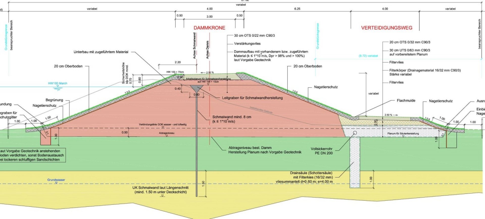
Development height
The design load case of the flood protection system is a flood with a 100-year probability of occurrence (HW100), whereby the dam crest was extended to the respective intergovernmentally agreed development heights (HW100 + 70 cm along the Morava and HW100 + 100 cm along the Thaya). In some sections, the upper edge of the dam approved by the water authorities was higher than the intergovernmentally agreed development target; in this case, the level of the approval was the basis for the rehabilitation.
Remaining work
In the course of the remaining work, the final kilometre markings of the dam were determined and made visible with kilometre stones. At the same time, uniform staff gauges were erected at the culverts to document the water levels during flood events.
Drainage pipes and pumping stations were built for the discharge of the foul water from the surface layer relaxation (gravel column water) to low points near the dam and conveyance over the dam into the Morava. The locations of the pumping stations were agreed in detail with the mayors, local farmers' representatives and residents.
In the Bernhardsthal area, the dam crest of an approximately 11-kilometre-long section (above the Rabensburg cross-dam) is to be rehabilitated. The detailed technical planning was carried out in 2016 and construction began in autumn 2018. Construction is expected to take about 1.5 years.
Clients and financing
Project organisation
The project is being carried out on behalf and for the account of the two flood protection associations ("Wasserverband für den March-Thaya-Hochwasserschutzdamm Angern-Bernhardsthal" and "Wasserverband für den Marchhochwasserschutzdamm Marchegg-Zwerndorf"). Project management and control is carried out by viadonau.
Financing
The project is largely financed (phases 1-3) by the Federal Ministry of Transport, Innovation and Technology (BMVIT), which is responsible for the strategic planning, management and control of all tasks assigned to viadonau by the Federal Waterways Administration. For the planning and construction works of the feeder creeks, the province of Lower Austria as well as the municipalities concerned contributed to the financing.
Cost estimate
In total, approx. 125 million euros (including the VAT incurred by the water associations) will be invested in the rehabilitation of the flood protection dams.
Ecological measures
In the context of construction measures, the preservation of valuable habitats, such as the Natura 2000 protected area for amphibians and birds, is an important task. Construction schedules are therefore drawn up with consideration for the rare breeding and water birds of the region. The erection of protective fences at the construction sites makes it possible, for example, to protect frogs and toads from the ongoing construction work. For the greening of the finished dam, existing humus material and native dry grassland seeds are used. By means of a cut-off wall, it will be possible to prevent the dam from seeping through in the future. The so-called cover layer relaxation protects against a dam failure caused by the uplift force of the groundwater. This means that the dams can reliably withstand any flooding. Nevertheless, the groundwater can flow into the floodplain forest and wetlands as before.
